Cardinal Greenways offers multiple map formats to help you plan your route and to find trailheads along the way.
Our interactive trail map allows you to get directions to any trailhead. You can also print the map by clicking the “Printable Map” button below. There are 62 miles of trail on the Cardinal Greenway, plus an additional 15 mile road section from Gaston to Jonesboro.
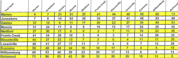
Looking for distances between trailheads? Use our mileage calculator below to determine the distance for your next trip on the Cardinal Greenway!
To use the calculator, find your starting point on the left column and your destination on the top row. Where the two places meet indicates the miles between them.